New UK Book Provides Perspectives For Navigating Uncertain Times

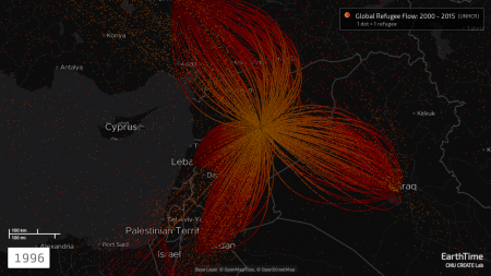
Earthtime refugee flow
EarthTime, the innovative data visualization technology developed by Carnegie Mellon University’s CREATE Lab, takes center stage in a new book addressing some of the greatest challenges facing mankind.
“Terra Incognita: 100 Maps to Survive the Next 100 Years,” is being published by Century, an imprint of Penguin Random House UK. Written by Ian Goldin, a professor of global development at Oxford University, and Robert Muggah, a Canadian political scientist who specializes on security, cities and new technology, the book includes satellite maps and data visualizations by the CREATE Lab team of Paul Dille, Gabriel O’Donnell and Ryan Hoffman.
The book, not yet available in the U.S., visualizes and analyzes the impact of human activity on the planet and on society, examining such issues and mega-trends as pandemics, global climate change, inequality, violence, migration, health, education and accelerating technologies. The publisher says it plans to support the book with a social media campaign featuring the book’s visualizations as short online videos.
“We hope that this book gives readers both context and optimism about the global challenges we face,” said Hoffman, CREATE Lab project manager. “It helps shift the discussion away from the sensationalist narratives we see on social media and in the news. By leveraging powerful maps and the latest scientific evidence, this book can help shape solution-oriented discourse.”
In publicity materials released for the book, Steven Pinker, cognitive psychologist and popular science author, described Terra Incognita as “a riveting account of humanity’s most pressing problems and innovative solutions.” Arianna Huffington, co-founder of the Huffington Post, described it as an unflinching account of our challenges that “will leave your optimistic about the future.”

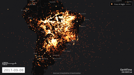
Earthtime Amazon night fires image
EarthTime evolved from CREATE Lab projects for creating and exploring panoramic imagery, eventually incorporating data sets from such sources as the United Nations, NASA, U.S. Geological Survey, the London School of Health and Tropical Disease and even the Housing Mortgage Disclosure Act. It thus became a powerful tool for visualizing data over time and space and is now an annual fixture at the World Economic Forum’s Davos conference. It also is used in education and, locally, for advocacy regarding housing and inequality.
Dille, senior software developer, said the team created dozens of new maps for the book to make the data as current and relevant as possible. Some of the newly visualized data was released only a few months ago.
“It is a historical irony that one of the most advanced visualization systems we have developed, EarthTime, lends itself powerfully to the creation of graphic imagery for a traditional hardcover book,” said Illah Nourbakhsh, professor of robotics and director of the CREATE Lab. “The combination of visuals and narratives that constitute Terra Incognita provide a never-before-seen depth of engagement, suitable for all, on how our planet is changing dramatically right under our feet.”