We have two robotic systems developed for acquiring accurate volumetric maps of underground mines. One system is based on a cart instrumented by laser range finders, pushed through a mine by people. Another (Groundhog) is a remotely controlled mobile robot equipped with laser range finders. To build consistent maps of large mines with many cycles, we describe an algorithm for estimating global correspondences and aligning robot paths. This algorithm enables us to recover consistent maps several hundreds of meters in diameter, without odometric information. We have tested the robots in two mines, a research mine in Bruceton, PA, and an abandoned coal mine in Burgettstown, PA.
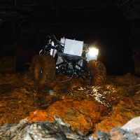
On October 27, 2002, the Groundhog robot was deployed in an abandoned coal mine, too toxic for people to enter (oxygen levels were too low for people to remain conscious). The previously flooded mine had been partially drained in the days before the experiment. Though the ground was still covered with toxic mud. the robot advanced more than 30 meters into the mine when the computer box flooded. A second experiment on October 29 led to an even deeper penetration, now with a water-sealed computer box. The robot was more than 50% submersed while a live video feed was broadcasted via satellites to a mine safety conference.
On May 30, 2003, Groundhog autonomously descended into the abandoned Mathies Mine near Pittsburgh, PA. The 1500-pound vehicle was equipped with laser range sensors, a night vision camera, gas detectors, sinkage sensors, and a gyroscope. 308 meters into the rapidly decaying mine, Groundhog encountered a broken ceiling beam that draped diagonally across the robot’s path. The robot made the appropriate decision to retreat.
past head
- Scott Thayer
past staff
- Christopher R. Baker
- Brett Browning
- David Silver
- Sebastian Thrun
past contact
- Scott Thayer


