Enhanced Road Network Data from Overhead Imagery
Project Head: Christopher Urmson
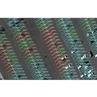
Digital maps are an essential resource for navigation by both autonomous and human driven vehicles. Digital maps are information rich but this information is difficult for an autonomous system to extract. Our initial research applies hierarchical image processing and machine learning techniques to extract a compact representation of parking lot geometry.
Displaying 6 Publications
2010
Tech. Report, CMU-RI-TR-10-36, Robotics Institute, Carnegie Mellon University, October, 2010
Conference Paper, Proceedings of (IROS) IEEE/RSJ International Conference on Intelligent Robots and Systems, pp. 6052 - 6057, October, 2010
2009
Conference Paper, Proceedings of 17th ACM SIGSPATIAL International Conference on Advances in Geographic Information Systems (GIS '09), pp. 13 - 22, November, 2009
Conference Paper, Proceedings of (IROS) IEEE/RSJ International Conference on Intelligent Robots and Systems, pp. 339 - 344, October, 2009
Conference Paper, Proceedings of 21st International Joint Conference on Artificial Intelligence (IJCAI '09), July, 2009
Tech. Report, CMU-RI-TR-09-03, Robotics Institute, Carnegie Mellon University, 2009